Walk Audit Around UTA, with Walkable Arlington
I participated in a walk audit organized by Walkable Arlington, a student-led grassroots organization partnered with University of Texas, Arlington.
By Hexel Colorado on March 13, 2023
On Saturday, February 25th, I participated in a walk audit organized by Walkable Arlington, a student-led grassroots organization partnered with University of Texas, Arlington. Approximately 30 people split into 4 teams and were assigned a few blocks each to observe for walkability issues.
My team started by assessing Mitchell Street between South Cooper and the pedestrian bridge connecting the parking lot to the opposite side of Mitchell Street.
Paths to Nothing
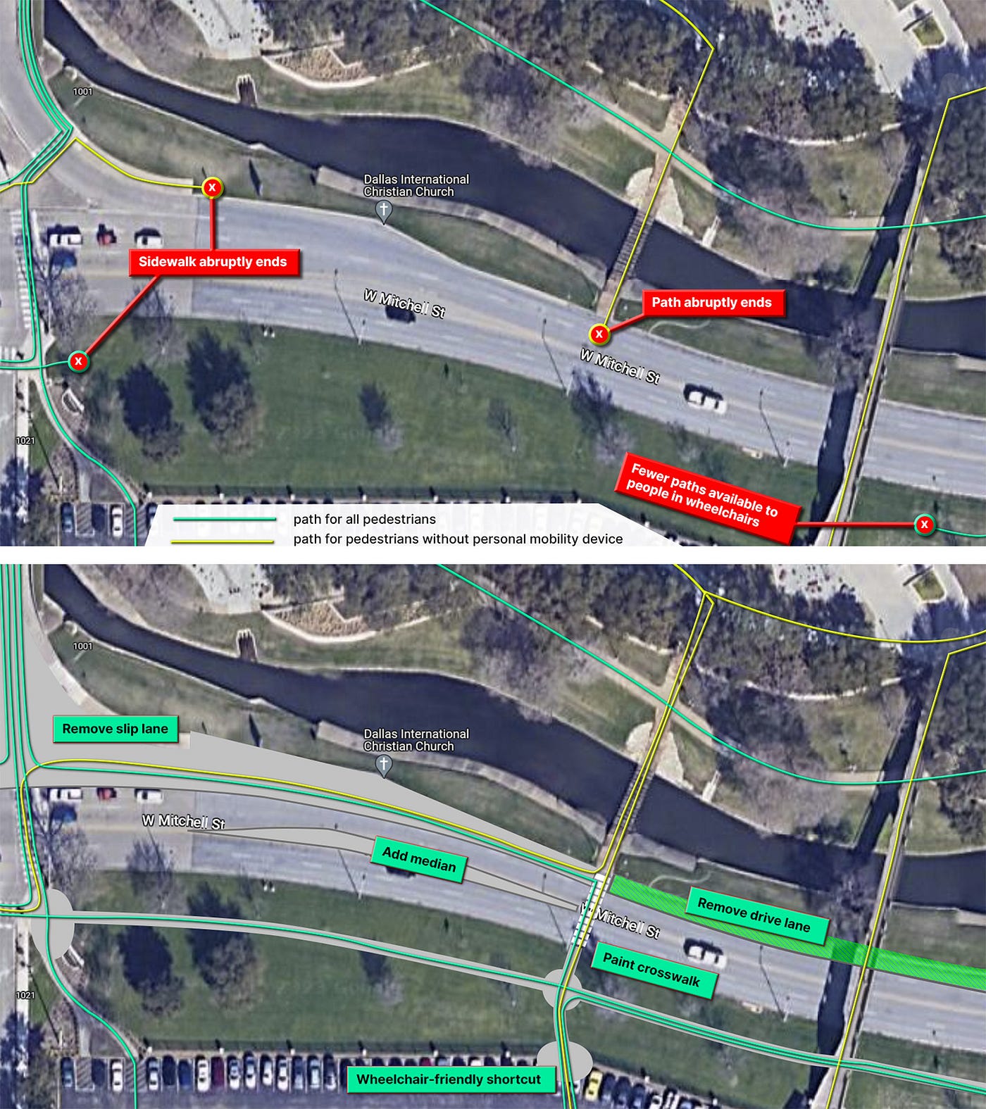 FIGURE 1: The top image shows where paths abruptly end. The bottom image illustrates recommendations to increase wheelchair accessibility and improve safety for pedestrians crossing W Mitchell St.
Pedestrian paths often led to roadbed for no apparent reason; paths led to curbs with neither wheelchair ramps nor painted crosswalks. The southside of Mitchell Street does not have sidewalk; this limits the movement options available to pedestrians, especially for people in wheelchairs. Although the pedestrian bridge is convenient for able-bodied people, it does not serve people in wheelchairs.
RECOMMENDATIONS: (a) remove the slip lane and one drive lane; (b) add median; (c) add midblock crossing with ramp and crosswalk paint; and (d) add sidewalk along southside of Mitchell Street.
Applying these changes would improve pedestrian safety by calming the speed of cars and reducing the crossing distance for pedestrians. They also give wheelchair users more accessible movement options.
Vehicle Speed & Wayfinding
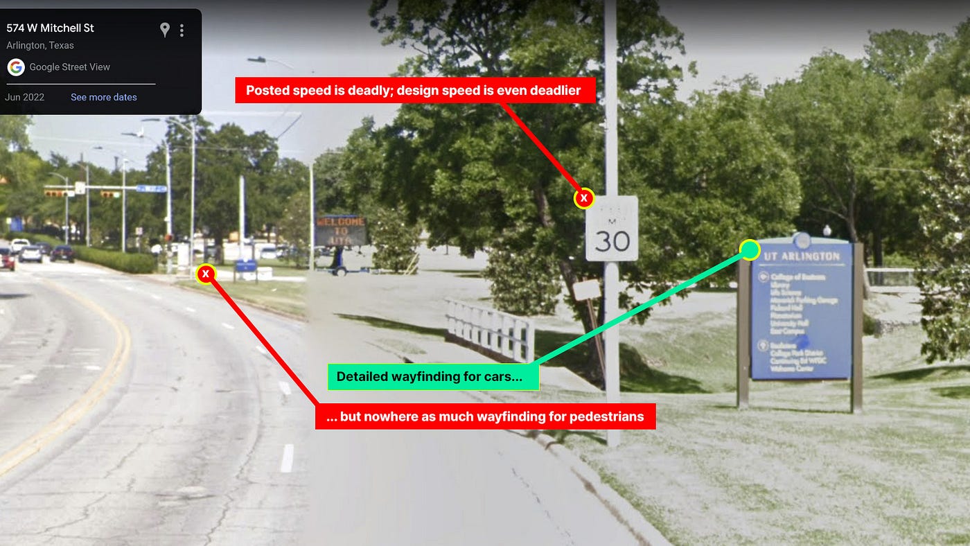 FIGURE 2: Pedestrians don’t enjoy the same wayfinding facilities as cars do.
The wayfinding sign is probably not a dangerous distraction when vehicles move at a safe slow speed. However, it can be a dangerous distraction for vehicles moving at the deadly posted speed limit of 30mph. Without any form of traffic calming on the four-lane road, cars are induced to move at speeds higher and deadlier than the posted limit. It’s also worth noting how pedestrians don’t have the same level of detailed wayfinding as cars do.
Intersection Needs Upgrade
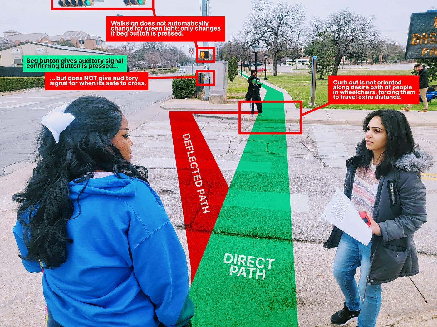 FIGURE 3: Due to the orientation of curb ramps, wheelchair users must take an indirect longer path when crossing the street.
This wasn’t the worst intersection I’ve ever encountered; at least the beg buttons were functional. However, as observed in photo above, the walk sign does not automatically turn on when the traffic light turns green.
A win for visually impaired pedestrians: pressing the beg button emits a voice that says, “wait to cross West Mitchell Street.” However, no audio signal is emitted when the walk sign turns on.
Curb ramps allow wheelchair users to cross the intersection. However, the curb cuts are oriented in such a way that people in wheelchairs must travel an indirect path across the street.
RECOMMENDATIONS: cut additional curb ramps and upgrade walk signal.
Applying these changes would making crossing safer for visually impaired people and more convenient for people in wheelchairs.
Plan Movement from Bus Stops
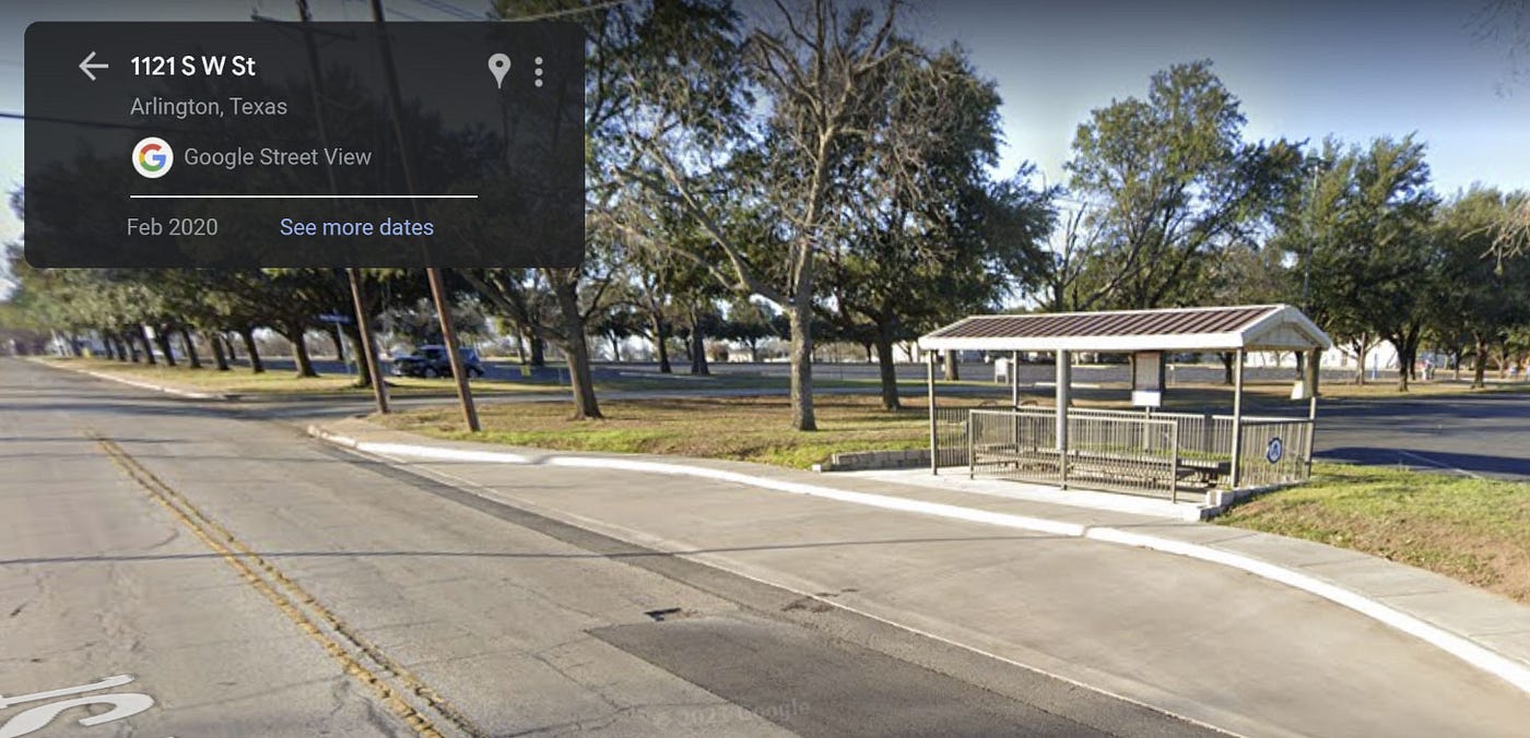 FIGURE 4: Bus stop shelter on South W Street.
The bus shelter on S W Street is pretty nice compared to most shelters: it’s roomy, has plenty of seating, easily shelters people in wheelchairs, and is connected to a sidewalk in good condition. I searched and did not find a light for illuminating the shelter at night.
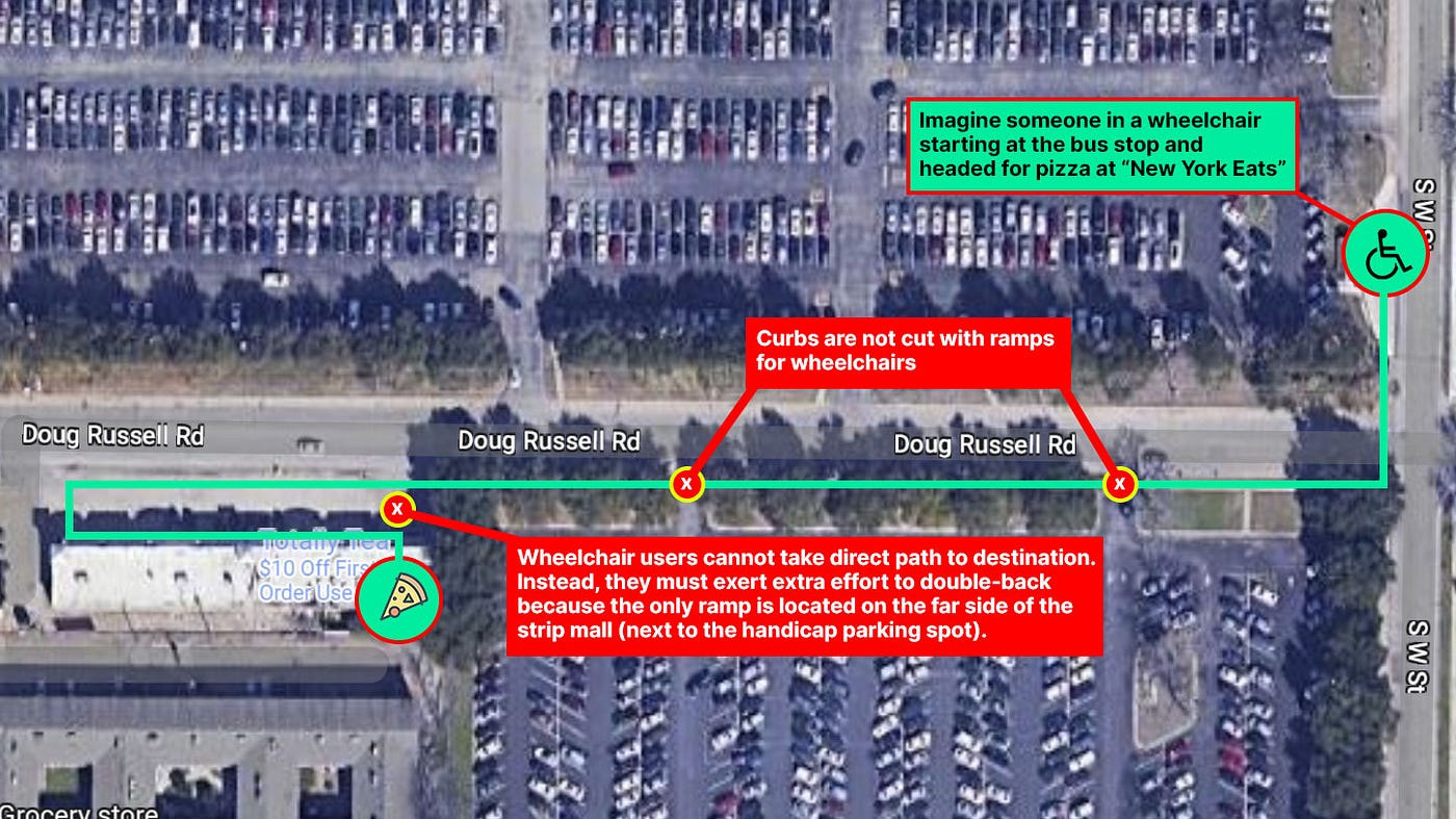 FIGURE 5: Several hurdles make it extremely difficult for wheelchair users starting from the bus stop to make it to their final destination.
In compliance with ADA requirements, the strip mall on Doug Russell Road has a wheelchair ramp right next to the handicap parking on the west end of the strip. However, wheelchair users approaching the strip from the bus stop to the east must dodge cars in the strip parking lot and travel double-distance because an accessible ramp is not available on the east end.
Movement on wheelchairs is also made prohibitively difficult by the total lack of curb ramps in the sidewalk along Doug Russell Road.
Double-Wide Lanes
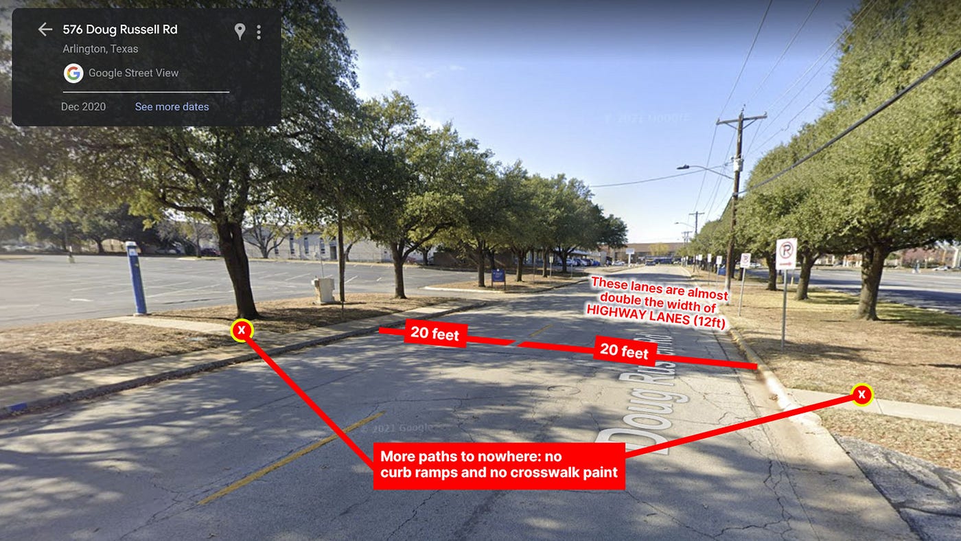 FIGURE 6: Doug Russell Road is dangerously twice as wide as it should be.
The minimum width for highway drive lanes in Texas is 12 feet. Each lane on Doug Russell Rd is 20 feet. This means people leaving their parked car must walk onto a road shared with cars that may be moving at highway speeds.
Just as our walk audit team had the measuring tape out to confirm the lane widths, we witnessed a car dangerously speed up to jockey around another car that had slowed down in front of it. With zero protections from speeding vehicles, this double-wide road is a death trap for pedestrians.
Solution #1: Test narrowing roads ASAP
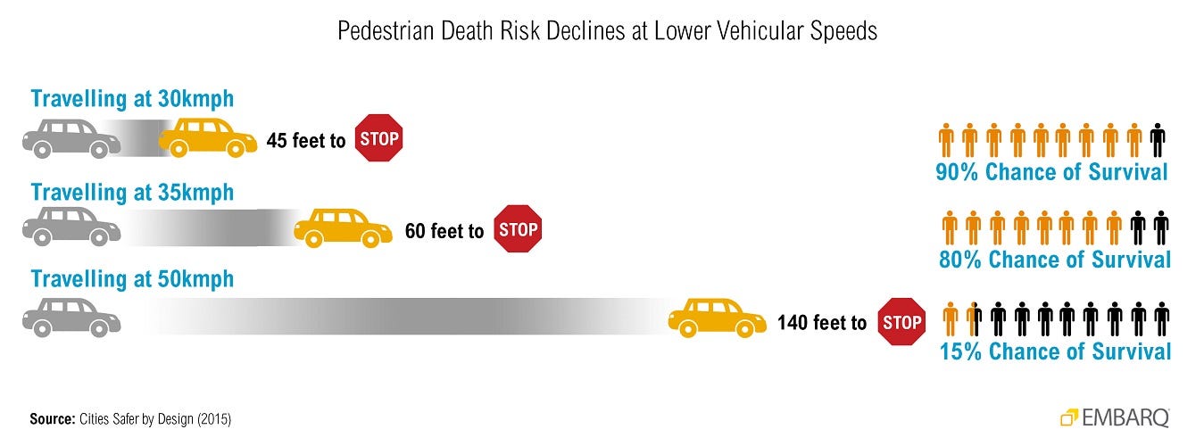 FIGURE 7: A pedestrian’s chance of survival drops 65% between 21mph and 31mph.
Most local streets in the United States have lanes 12 feet wide. However, a lane width of 10 feet is recommended on streets shared between cars and people. Making roads narrower makers them safer because doing so lowers the average speed of vehicles.
There is a myriad of ways to make use of surplus lane width: bike lanes, wider sidewalks, bus lanes, street trees, on-street parking, and more. Although it takes time to find the best permanent solution for a given road, there’s no practical risk from applying temporary measures to narrow the road. Rather than speculate over whether or not it’s a good idea to narrow a road, just put up something inexpensive and temporary — like traffic cones, rope, and spray paint— to perform a real-world traffic test.
Cities can decide on a permanent solution after temporary tests prove car traffic can get by just fine on narrower lanes. In the meantime, temporary tests can immediately save lives by making the road safer and easier for pedestrians to cross.
Solution #2: Paint crosswalks ASAP
The best things to do first are solutions that are highly effective in proportion to their low cost, are low-stake, and are easy to undo in case of mistakes.
Although painting crosswalks are not the biggest thing a city can do, it’s the lowest cost action that makes a real difference in pedestrian safety. It’s also the most difficult to mess up; just paint lines where we want people to walk and where cars should slow down and yield.
Solution #3: ALWAYS trial with wheelchairs
These weren’t the worst pedestrian facilities I’ve ever seen. But most problems seem to stem from the same fundamental issue: disregard for wheelchair users, especially those who ride the bus.
When planning for pedestrian movement, don’t forget people in wheelchairs. Further, don’t make the mistake of only looking at how wheelchair users move from the handicapped parking spot to their destination; make sure mobility-impaired transit riders have equitable access to destinations just like everybody else.
“Truly I tell you, whatever you did for one of the least of these brothers and sisters of mine, you did for me.”