DART Trip Review: Henderson Ave to Pegasus Park
6-mile midday bus trip from Lowest Greenville to an office park near the Medical District. A bicycle or scooter can cut hour-long trip in half, but the ideal solution from DART would be a non-stop east-west BRT line.
By Hexel Colorado on March 21, 2023
Living car free in Dallas requires advanced planning of any trip greater than 3-miles. As an advocate for better transit, I’m in the habit of imagining how certain trips could be made faster or more convenient. This article is my first attempt at breaking my bad habit of letting these brainstorms go to waste by not documenting my process.
I write this article with two readers in mind:
- DART planners: I hope this (and future such articles) help inform the next iteration of the bus and rail network.
- Dallas-area transit riders: You might find useful tips in my approach to multi-modal travel across the city.
The Task
Attend an afternoon workshop (Active Bystander Training hosted by 24HourDallas) at Pegasus Park near the Medical District. I work from home, so I will depart from my apartment in Old East Dallas, off Henderson Ave near Lowest Greenville. I must arrive at the event by 2:00pm.
Looking For a Plan
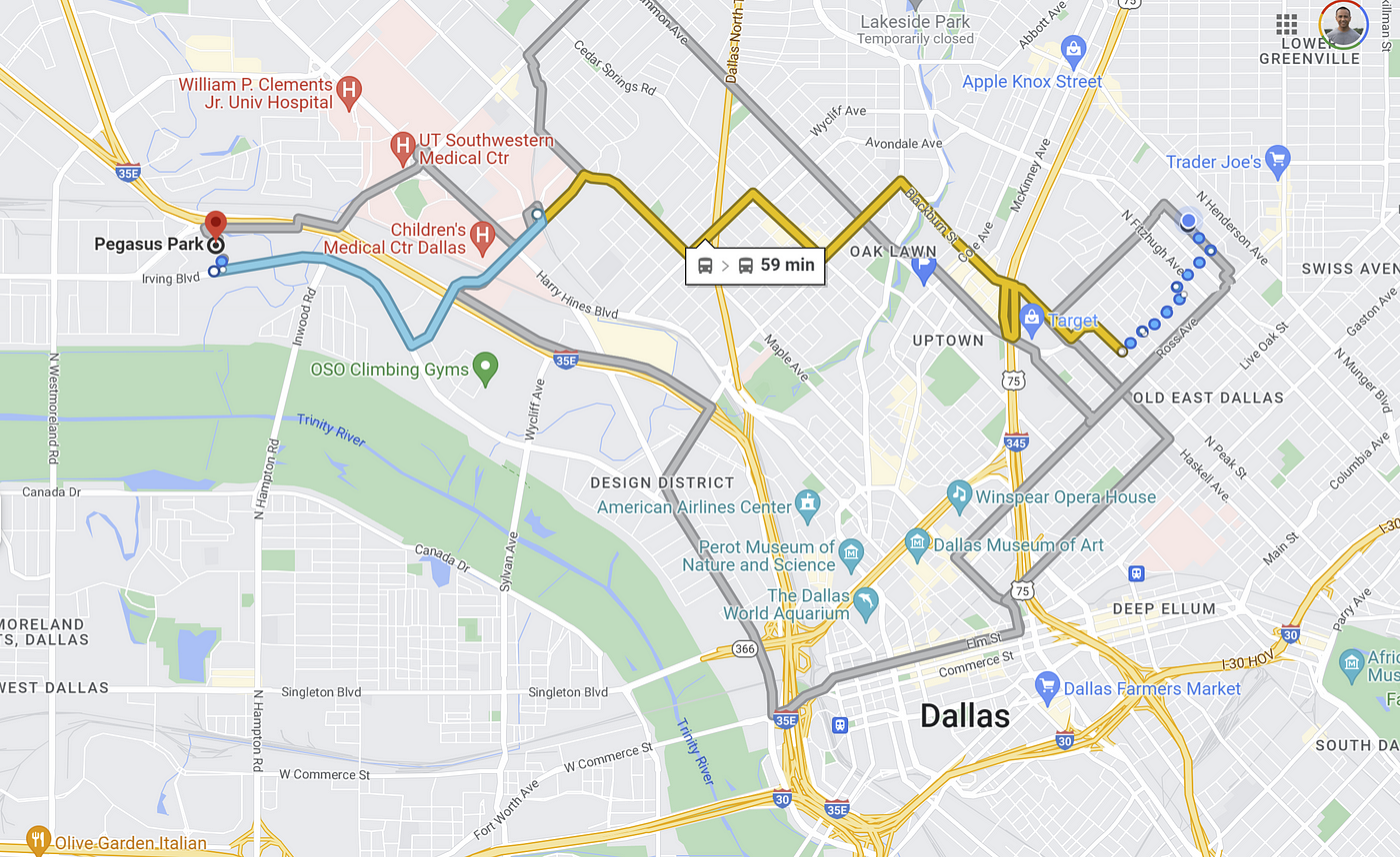
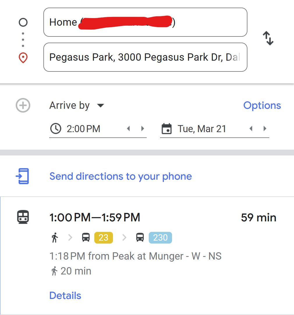
FIRST LOOK: 1-mile walk + 2 buses = 57 minutes
Google Maps is the most convenient way to get a first glance at what my route may be and how long it could take. I set the “Arrive by” time to 2:00 pm so that the recommended routes will be based on bus schedules for the appropriate time of day.
The most direct route involves…
- 20 minutes of walking to the first bus stop,
- 21-minute ride on Bus 23,
- 8-minute wait at SWMD/Parkland Station, and
- 8-minute ride on Bus 230, which drops me in front of my destination.
This transit itinerary takes 57 minutes of travel time. By comparison, Google estimates 22 minutes of travel time by car.
Thirty-Minute Limit
The difference between 57 minutes by transit and 22 minutes by car is quite significant. Before I learned about Marchetti’s Constant, I already made a subconscious decision that 30-minutes was my threshold for choosing transit over car in most situations. Here’s what I mean…
30mins or less = transit always. When choosing between car and transit, I (almost) always choose taking transit over a car if the transit trip is 30 minutes or less. This rule applies even if the same trip would take only 10 or 15 minutes by car. I’ll also always choose transit if both car and transit would take between 30 and 60 minutes.
Simple! Or at least, simple for me after a year of practice. You develop an instinct for this kind of thing over time; it’s no different than learning to predict how bad traffic will be during rush hour or rainy weather.
More than 30mins = negotiate. If the trip by transit is greater than 30 minutes and the trip by car is estimated to be less than 30 minutes, then I’ll consider alternatives to relying purely on transit. I may decide to take a car, but before I do, I’ll consider incorporating another mode into my transit trip; this often results in a multi-modal travel time within my 30-minute limit, thereby avoiding the use of a car.
In my case, my second mode is my e-bike.
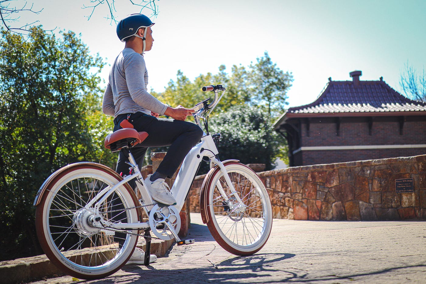 Me and my electric bicycle.
SECOND LOOK: 10mins on bicycle + 1 bus = 31 minutes
Honestly, I think I would have given up on living in Dallas without a car a long time ago if I didn’t invest in an electric bicycle. When pedal-assist is at the highest power setting, my e-bike goes up to 24 mph. That’s doesn’t get me on the highway, but it does allow me to reliably cut Google’s estimated bicycle time in half.
By replacing my first walk and second bus with my e-bike, I cut 26 minutes out of my total trip time with transit.
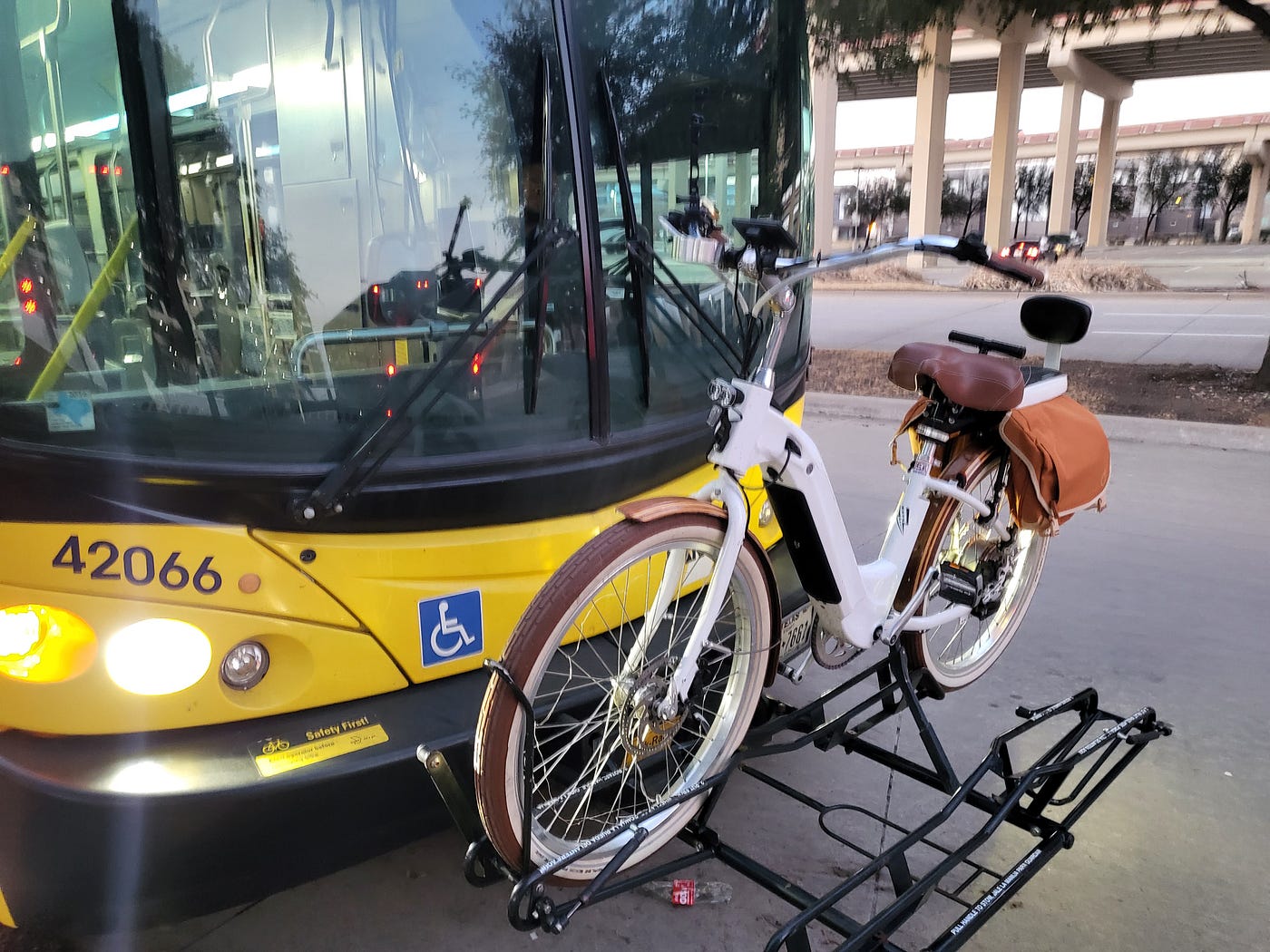 My bicycle mounted on standard racks at the front of a DART bus.
Every DART bus is equipped with a bicycle rack at the front. This allows me to use my bicycle for the first and last legs of my trip and ride the bus for the long middle distance.

Rather than wait at SWMD/Parkland Station to ride a bus for the last 2 miles, I ride my bicycle directly to my final destination.
At 31 minutes, this is a trip plan I’m comfortable with.
FINAL LOOK: all other options
Hailing a rideshare. The trip time by car is estimated to take up to 22 minutes. I don’t own a car; for me, taking a car means hailing a Lyft. It’s the most expensive approach, as well as the easiest. However, it’s not necessarily the fastest. The pursuit time can vary between 2 minutes and 15 minutes. I guesstimate my average wait time is 8 minutes, which means I wouldn’t save much time compared to a multimodal approach.
Riding e-bike for entire trip. Google’s estimated trip time for a typical bicycle is 39 minutes; I translate this to 20 minutes on my electric bicycle. This is significantly faster than incorporating a bus into my trip. It also carries some of the convenience of a car by allowing me to forgo bus schedules and embark on the trip at any minute. I often take this approach as Plan B in situations where I don’t leave home on time and miss my first bus.
If e-bike is often faster and more convenient, why bother with riding the bus at all? Three reasons:
- Cycling on Dallas streets carries risk. That’s not to say I never or rarely bike on Dallas streets; I’ve grown accustomed to sharing the road with cars, and I don’t doubt I’ll make it home safely each night. But if cycling only provides a minor convenience over transit, I’ll take the opportunity to lower my risk exposure and skip on tempting the odds.
- Keep my options open. Suppose I want to carpool with someone to my next activity. Or take a Lyft afterward. My bicycle is too big to fit in the trunk of a sedan, and trying to load it into an SUV is too much hassle.
- Sometimes transit is the easiest option of all. If I’m heading anywhere on Elm, Main, or Commerce Street, it’s really hard to beat just taking a bus or train.
What can DART improve?
The original transit trip of 59 minutes is not great. Roughly half an hour is spent on two things:
- Walking to the first bus stop (20 minutes)
- Waiting for the second bus (8 minutes)
Though I’m lucky to have two bus routes (105 and 3) within a short walk of my apartment, they only run north-south between downtown and Mockingbird Station. I’d like to see is a bus route with the following qualities:
- Runs east-west on either Henderson or Fitzhugh.
- Starting with the Dallas Arboretum in the east, moves west to connect Lowest Greenville, Oak Lawn, SWMD/Parkland Station, and Pegasus Park.
- Runs on dedicated bus lanes as it passes through Uptown, the highest density and most congested portion of the route.
The bullet points above would be my preferred solution. Ultimately, this trip would be made better by any solution that (A) cuts the transit trip time down to 30 minutes or less, and (B) shortens walking distance of first leg from 20 minutes to 5 minutes.